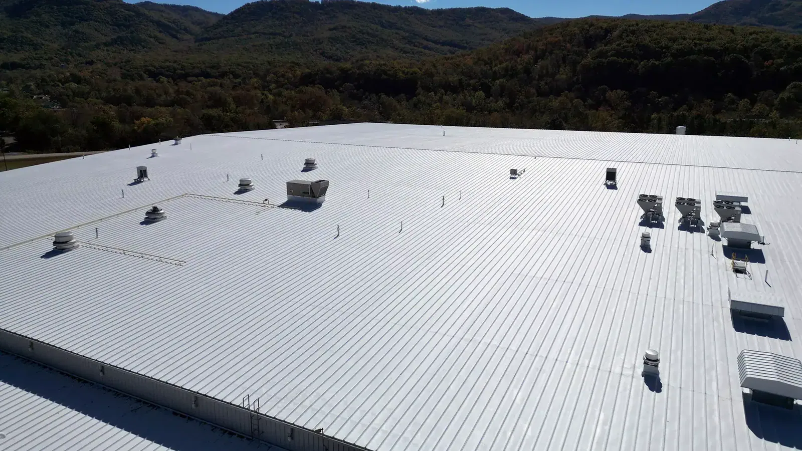
Drone Roof Inspection in Meridian, ID

Use drone roof inspection in Meridian, ID to capture overhead imagery, document hard-to-reach areas, and direct hands-on follow-up.

Drone Roof Inspection

Rows of rooftop units can hide a seam from ground level. A drone pass gives an overhead first read. It shows roof layout, visible debris, ponding patterns, and equipment spacing. In Meridian, we confirm the address and flight area. We also verify the site contact and restrictions. The pilot captures agreed views. We review the images and mark areas for hands-on inspection or roof access.

Drone imagery records visible conditions at a moment in time. It does not show concealed moisture or prove that a seam is watertight. Boise Air Terminal’s July average high is 92.7°F. That nearby reference frames heat review, not roof diagnosis. We check each surface directly. Near Silverstone Business Park, we coordinate launch and landing with the site contact. We protect office and meeting activity.

Set a safe flight area

Before launch, we confirm where the drone can fly and who controls the site. We check nearby activity and the views the owner needs. We mark lines, trees, exhaust, pedestrian routes, and other obstacles. Flight timing should fit site operations. The property contact provides access instructions and restricted areas. The pilot follows operating requirements and site rules.

The flight plan captures roof sections and edges. It also covers drains, skylights, and equipment from useful angles. We select views that make later comparison possible and label them by roof area. A blocked elevation or poor lighting limits the view. We note the limit and avoid inferring roof condition. Ten Mile Crossing includes offices, retail, restaurants, and medical services. We coordinate the launch point and timing with each property.

A drone can image hard-to-access areas. It cannot replace close inspection of a repair detail. Loose membrane or a damaged curb corner needs a close check. We arrange safe roof access before scoping repair. A full roof inspection adds close checks and interior context. We add those findings to the aerial record.

Capture useful roof evidence

We photograph roof areas in sequence. The owner can see location and scale. Images show unit layout, service paths, debris, surface changes, standing water, and edges. The photo log names each area and capture date. A dark patch is a visible finding, not a diagnosis. We check it closely before calling it a leak or membrane failure.

Imagery helps compare large roof areas. It can also revisit a location after repair. We mark seam lines, equipment perimeters, drain bowls, and access routes for follow-up. An image may show ponding. We inspect the drainage path and check whether water remains. The surface may be a single-ply membrane or another system. We confirm the material before recommending repair. One view cannot establish water depth, duration, or drain blockage. The field team checks those conditions directly.

Meridian plans for warehouses, storage, flex buildings, and light manufacturing. Broad roofs and dense equipment layouts can benefit from an overhead view. Land use does not identify the installed system. We identify the surface from records and hands-on review. The contact identifies the building and roof zones at El Dorado Business Campus.

Drone Roof Inspection in Meridian, ID

Direct the next inspection

After capture, we review the images with the owner or facility director. We tag visible concerns and obscured areas. The report lists the next checks by priority. Seam, flashing, and substrate questions need close inspection. We list those checks for follow-up. Images cannot confirm moisture beneath the membrane. We may recommend moisture survey work or test cuts.

Before launch, we agree on roof-zone names with the facility contact. We note view direction and capture time. Later reviewers can compare the same area. A labeled image shows where a seam or drain sits among equipment. It cannot show membrane feel or wet insulation. We send those questions to hands-on inspection or test cuts. The report keeps image clues separate from confirmed conditions.

Each image receives a roof-zone label. We retain its date and direction. Owners can compare views after repairs or equipment changes. We use the same zone names on the map and in the photo log. Maintenance staff can locate a finding without interpreting an unlabeled corner. If angles or lighting change, we note the comparison limit.

Imagery supports a condition report. It includes a roof map, labeled photos, and recommended actions. A drone view alone does not complete the diagnosis. At multi-building sites, we check which roofs fit the flight window. We identify each property contact. Eagle View Landing includes office, retail, medical, and corporate-campus spaces. Access can differ by building. We agree on scope with the property contact. Then we list areas needing a hands-on visit.

Drone Roof Inspection in Meridian, ID

Fit the flight into operations

We coordinate arrival, permission, flight area, and weather. A site contact should be available for questions. Wind, precipitation, low visibility, or nearby activity can limit or cancel the flight. If conditions are unsafe, we document the limit and reschedule. The site contact alerts tenants or security when property rules require notice.

Drone work can guide a larger inspection. Active water entry needs a timely response. For an active leak, dispatch needs the address, interior location, and access details. When water is entering now, dispatch can route an urgent visit overnight or on a holiday after confirming access. The crew selects an aerial pass, close inspection, or temporary protection based on conditions.

Before the visit, send roof plans, prior photos, and known restrictions. Aerial images are easier to use with equipment labels and a roof map. Without a plan, we create a location key. The site contact helps identify roof areas after the flight.

Drone Roof Inspection in Meridian, ID

Can a drone confirm whether a commercial roof is leaking?

Aerial imagery can show visible openings, debris, standing water, and layout. It cannot see through the roof or prove the source of an interior leak. We use the images to direct close inspection, compare with interior reports, and select moisture testing or a test cut when needed.

What roof details are easiest to document from above?

Large surface areas, equipment arrangements, access paths, visible debris, and some drainage and edge conditions can be captured well. Small seams, curb corners, and flashing terminations may need close photographs or hands-on review. We label image limits so a manager knows where another inspection is needed.

What can delay a scheduled drone visit?

Wind, rain, poor visibility, site restrictions, and activity near the flight area can change the plan. We confirm conditions and property permission before launch. If a safe view is not possible, the report identifies what was not captured and the next practical option.

Can you compare drone photos after a repair?

Yes, when the roof area and camera angles are comparable. We keep the date and location with each image and note differences in lighting or view. A close check remains necessary to verify repair materials and seams, but repeat imagery can help track visible changes across a broader area.
Plan an aerial roof review

Send the Meridian address, roof plan if available, areas of concern, site contact, and any flight restrictions. We will set a capture window, label the imagery, and identify where hands-on or moisture testing should follow.

Call 555-555-5555 or fill out the form and we will be in touch.

Got a Leak?

For active leaks, storm damage or other urgent roof problems, call us directly at: 555-555-5555.

ServicesRoof SystemsProperty TypesIndustriesService AreasDamage RepairCapabilitiesManufacturersAboutRequest a Roof Assessment555-555-5555
Call555-555-5555